 |
 |
|
|
| Station Name (GRDC ID): | Sarh(Fort Archambault) (1537500) | Basin Name: | Chari |
|---|---|---|---|
| River Name: | Chari | Next Downstream Station: | Bousso (1537300) |
| GRDC Country Code: | CD | Distance to Next Downstream Station: | 367 km |
| Start Year [Month]: | 1938 [1] | Upstream Station(s): | Golongosso (1737700) |
| End Year [Month]: | 1986 [4] | ||
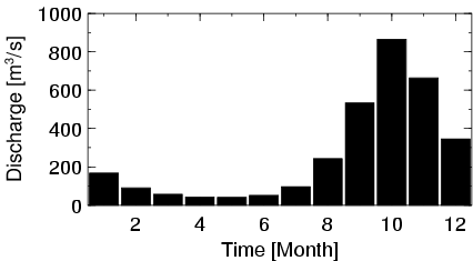
| Mean Discharge: | 266 m3/s | ||
| Minimum Discharge: | 0 m3/s | ||
| Maximum Discharge: | 1912 m3/s | Length of Upstream Mainstem: | 767 km |
| Mean Interstation Discharge: | 192 m3/s | Distance to Basin Outlet: | 766 km |
| GRDC Catchment Area: | 193000 km2 | STN Catchment Area: | 177081 km2 |
| GRDC Interstation Area: | 97000 km2 | STN Interstation Area: | 73504 km2 |
| GRDC Station Runoff: | 44 mm/yr | STN Station Runoff: | 47 mm/yr |
| GRDC Interstation Runoff: | 62 mm/yr | STN Interstation Runoff: | 82 mm/yr |
| Station Field Descriptions | Basin Field Descriptions | ||
| Download | |
|---|---|
| Site Descriptor Information | Station Time Series Data |
| Hydrograph | Station Data | ||||||||||||||||||||||||||||||||||||||||||||||||||||||||
|---|---|---|---|---|---|---|---|---|---|---|---|---|---|---|---|---|---|---|---|---|---|---|---|---|---|---|---|---|---|---|---|---|---|---|---|---|---|---|---|---|---|---|---|---|---|---|---|---|---|---|---|---|---|---|---|---|---|
|
| ||||||||||||||||||||||||||||||||||||||||||||||||||||||||
