 |
 |
|
|
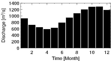
| Station Name (GRDC ID): | Malakal (1673600) | Basin Name: | Nile |
|---|---|---|---|
| River Name: | White Nile | Next Downstream Station: | Mogren (1673100) |
| GRDC Country Code: | SU | Distance to Next Downstream Station: | 789 km |
| Start Year [Month]: | 1912 [1] | Upstream Station(s): | Mongalla (1673900) |
| End Year [Month]: | 1982 [12] | ||
| Mean Discharge: | 939 m3/s | ||
| Minimum Discharge: | 331 m3/s | ||
| Maximum Discharge: | 2396 m3/s | Length of Upstream Mainstem: | 2344 km |
| Mean Interstation Discharge: | -112 m3/s | Distance to Basin Outlet: | 3620 km |
| GRDC Catchment Area: | 1080000 km2 | STN Catchment Area: | 1185196 km2 |
| GRDC Interstation Area: | 630000 km2 | STN Interstation Area: | 629315 km2 |
| GRDC Station Runoff: | 27 mm/yr | STN Station Runoff: | 25 mm/yr |
| GRDC Interstation Runoff: | -6 mm/yr | STN Interstation Runoff: | -6 mm/yr |
| Station Field Descriptions | Basin Field Descriptions | ||
| Download | |
|---|---|
| Site Descriptor Information | Station Time Series Data |
| Hydrograph | Station Data | ||||||||||||||||||||||||||||||||||||||||||||||||||||||||
|---|---|---|---|---|---|---|---|---|---|---|---|---|---|---|---|---|---|---|---|---|---|---|---|---|---|---|---|---|---|---|---|---|---|---|---|---|---|---|---|---|---|---|---|---|---|---|---|---|---|---|---|---|---|---|---|---|---|
|
| ||||||||||||||||||||||||||||||||||||||||||||||||||||||||
