 |
 |
|
|
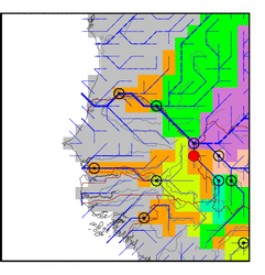
| Station Name (GRDC ID): | Kidira (1812600) | Basin Name: | Senegal |
|---|---|---|---|
| River Name: | Faleme | Next Downstream Station: | Bakel (1812500) |
| GRDC Country Code: | SG | Distance to Next Downstream Station: | 56 km |
| Start Year [Month]: | 1930 [5] | Upstream Station(s): | Gourbassy (1112200) |
| End Year [Month]: | 1989 [3] | ||
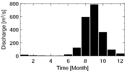
| Mean Discharge: | 170 m3/s | ||
| Minimum Discharge: | 0 m3/s | ||
| Maximum Discharge: | 1805 m3/s | Length of Upstream Mainstem: | 377 km |
| Mean Interstation Discharge: | 52 m3/s | Distance to Basin Outlet: | 678 km |
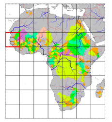
| GRDC Catchment Area: | 28900 km2 | STN Catchment Area: | 33114 km2 |
| GRDC Interstation Area: | 13900 km2 | STN Interstation Area: | 18022 km2 |
| GRDC Station Runoff: | 185 mm/yr | STN Station Runoff: | 162 mm/yr |
| GRDC Interstation Runoff: | 119 mm/yr | STN Interstation Runoff: | 92 mm/yr |
| Station Field Descriptions | Basin Field Descriptions | ||
| Download | |
|---|---|
| Site Descriptor Information | Station Time Series Data |
| Hydrograph | Station Data | ||||||||||||||||||||||||||||||||||||||||||||||||||||||||
|---|---|---|---|---|---|---|---|---|---|---|---|---|---|---|---|---|---|---|---|---|---|---|---|---|---|---|---|---|---|---|---|---|---|---|---|---|---|---|---|---|---|---|---|---|---|---|---|---|---|---|---|---|---|---|---|---|---|
|
| ||||||||||||||||||||||||||||||||||||||||||||||||||||||||
