 |
 |
|
|
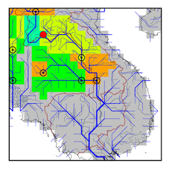
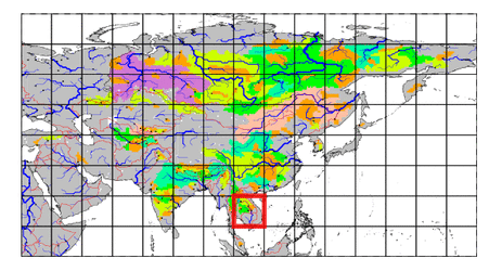
| Station Name (GRDC ID): | Nong Khai (2969090) | Basin Name: | Mekong |
|---|---|---|---|
| River Name: | Mekong | Next Downstream Station: | Mukdahan (2969100) |
| GRDC Country Code: | TH | Distance to Next Downstream Station: | 415 km |
| Start Year [Month]: | 1980 [4] | Upstream Station(s): | Luang Prabang (2469050) |
| End Year [Month]: | 1993 [12] | ||
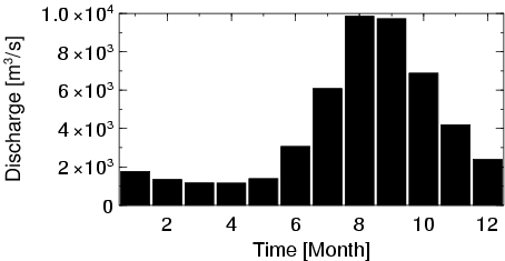
| Mean Discharge: | 4084 m3/s | ||
| Minimum Discharge: | 967 m3/s | ||
| Maximum Discharge: | 16067 m3/s | Length of Upstream Mainstem: | 2586 km |
| Mean Interstation Discharge: | 458 m3/s | Distance to Basin Outlet: | 1468 km |
| GRDC Catchment Area: | 302000 km2 | STN Catchment Area: | 305079 km2 |
| GRDC Interstation Area: | 34000 km2 | STN Interstation Area: | 26387 km2 |
| GRDC Station Runoff: | 426 mm/yr | STN Station Runoff: | 422 mm/yr |
| GRDC Interstation Runoff: | 425 mm/yr | STN Interstation Runoff: | 548 mm/yr |
| Station Field Descriptions | Basin Field Descriptions | ||
| Download | |
|---|---|
| Site Descriptor Information | Station Time Series Data |
| Hydrograph | Station Data | ||||||||||||||||||||||||||||||||||||||||||||||||||||||||
|---|---|---|---|---|---|---|---|---|---|---|---|---|---|---|---|---|---|---|---|---|---|---|---|---|---|---|---|---|---|---|---|---|---|---|---|---|---|---|---|---|---|---|---|---|---|---|---|---|---|---|---|---|---|---|---|---|---|
|
| ||||||||||||||||||||||||||||||||||||||||||||||||||||||||
