 |
 |
|
|
| Station Name (GRDC ID): | Aruma-Jusante (3625310) | Basin Name: | Amazon |
|---|---|---|---|
| River Name: | Rio Purus | Next Downstream Station: | Obidos (3629000) |
| GRDC Country Code: | BZ | Distance to Next Downstream Station: | 837 km |
| Start Year [Month]: | 1975 [12] | Upstream Station(s): | Labrea (3625340) |
| End Year [Month]: | 1993 [4] | ||
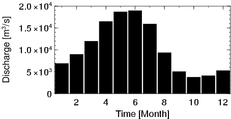
| Mean Discharge: | 10435 m3/s | ||
| Minimum Discharge: | 2774 m3/s | ||
| Maximum Discharge: | 24538 m3/s | Length of Upstream Mainstem: | 1744 km |
| Mean Interstation Discharge: | 4865 m3/s | Distance to Basin Outlet: | 1374 km |
| GRDC Catchment Area: | 359853 km2 | STN Catchment Area: | 360991 km2 |
| GRDC Interstation Area: | 139502 km2 | STN Interstation Area: | 119834 km2 |
| GRDC Station Runoff: | 914 mm/yr | STN Station Runoff: | 912 mm/yr |
| GRDC Interstation Runoff: | 1100 mm/yr | STN Interstation Runoff: | 1280 mm/yr |
| Station Field Descriptions | Basin Field Descriptions | ||
| Download | |
|---|---|
| Site Descriptor Information | Station Time Series Data |
| Hydrograph | Station Data | ||||||||||||||||||||||||||||||||||||||||||||||||||||||||
|---|---|---|---|---|---|---|---|---|---|---|---|---|---|---|---|---|---|---|---|---|---|---|---|---|---|---|---|---|---|---|---|---|---|---|---|---|---|---|---|---|---|---|---|---|---|---|---|---|---|---|---|---|---|---|---|---|---|
|
| ||||||||||||||||||||||||||||||||||||||||||||||||||||||||
