 |
 |
|
|
| Station Name (GRDC ID): | Nagymaros (6442500) | Basin Name: | Danube |
|---|---|---|---|
| River Name: | Danube(Duna) | Next Downstream Station: | Mohacs (6442600) |
| GRDC Country Code: | HU | Distance to Next Downstream Station: | 178 km |
| Start Year [Month]: | 1893 [1] | Upstream Station(s): | Bratislava (6142200) |
| End Year [Month]: | 1995 [12] | ||
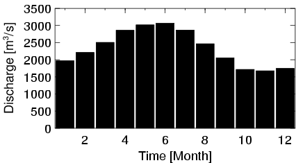
| Mean Discharge: | 2346 m3/s | ||
| Minimum Discharge: | 628 m3/s | ||
| Maximum Discharge: | 7056 m3/s | Length of Upstream Mainstem: | 943 km |
| Mean Interstation Discharge: | 299 m3/s | Distance to Basin Outlet: | 1334 km |
| GRDC Catchment Area: | 183533 km2 | STN Catchment Area: | 182903 km2 |
| GRDC Interstation Area: | 52195 km2 | STN Interstation Area: | 51417 km2 |
| GRDC Station Runoff: | 403 mm/yr | STN Station Runoff: | 404 mm/yr |
| GRDC Interstation Runoff: | 181 mm/yr | STN Interstation Runoff: | 183 mm/yr |
| Station Field Descriptions | Basin Field Descriptions | ||
| Download | |
|---|---|
| Site Descriptor Information | Station Time Series Data |
| Hydrograph | Station Data | ||||||||||||||||||||||||||||||||||||||||||||||||||||||||
|---|---|---|---|---|---|---|---|---|---|---|---|---|---|---|---|---|---|---|---|---|---|---|---|---|---|---|---|---|---|---|---|---|---|---|---|---|---|---|---|---|---|---|---|---|---|---|---|---|---|---|---|---|---|---|---|---|---|
|
| ||||||||||||||||||||||||||||||||||||||||||||||||||||||||
