 |
 |
|
|
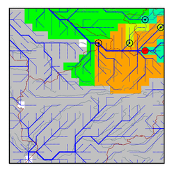
| Station Name (GRDC ID): | Niz. Pjandge (2917950) | Basin Name: | Amu-Darya |
|---|---|---|---|
| River Name: | Pjandge | Next Downstream Station: | Kerki (2917110) |
| GRDC Country Code: | TA | Distance to Next Downstream Station: | 292 km |
| Start Year [Month]: | 1965 [1] | Upstream Station(s): | Khorog (2917700) Murgab (2917830) |
| End Year [Month]: | 1989 [12] | ||
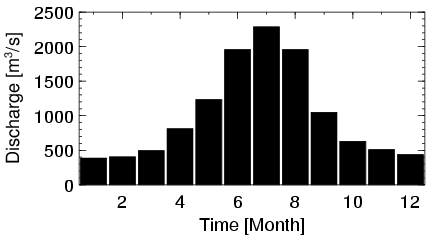
| Mean Discharge: | 1012 m3/s | ||
| Minimum Discharge: | 309 m3/s | ||
| Maximum Discharge: | 3280 m3/s | Length of Upstream Mainstem: | 722 km |
| Mean Interstation Discharge: | 892 m3/s | Distance to Basin Outlet: | 1299 km |
| GRDC Catchment Area: | 113000 km2 | STN Catchment Area: | 105343 km2 |
| GRDC Interstation Area: | 88800 km2 | STN Interstation Area: | 83230 km2 |
| GRDC Station Runoff: | 283 mm/yr | STN Station Runoff: | 303 mm/yr |
| GRDC Interstation Runoff: | 317 mm/yr | STN Interstation Runoff: | 338 mm/yr |
| Station Field Descriptions | Basin Field Descriptions | ||
| Download | |
|---|---|
| Site Descriptor Information | Station Time Series Data |
| Hydrograph | Station Data | ||||||||||||||||||||||||||||||||||||||||||||||||||||||||
|---|---|---|---|---|---|---|---|---|---|---|---|---|---|---|---|---|---|---|---|---|---|---|---|---|---|---|---|---|---|---|---|---|---|---|---|---|---|---|---|---|---|---|---|---|---|---|---|---|---|---|---|---|---|---|---|---|---|
|
| ||||||||||||||||||||||||||||||||||||||||||||||||||||||||
